
Ever since I was a child, I have been fascinated by the planes flying over North Mayo and their vapour trails that criss-cross the sky on a clear day, evidence of Mayo’s location as one of the key North Atlantic routes for trans-Atlantic aircraft.
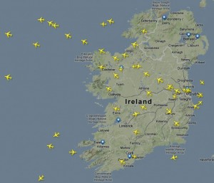
A Flightradar24 screenshot of the busy skies over County Mayo showing aircraft heading out into the North Atlantic on their way to North America, flying between the altitudes of 28,500 and 42,000 feet.
So it was hardly surprising that I was one of the early adopters of the flight tracker app for iPhone and Android, Flightradar 24, which shows you all the information you need to know about the plane flying overhead.
The website and App has a goldmine of information about the particular plane flying overhead such as the airport the plane originated from, its final destination, altitude, speed and a real-time 3D view of the flight path.
County Mayo is a great location for aircraft spotting as it is one the North Atlantic Tracks (NAT) – used by aircraft traveling between North America and Europe, flying between the altitudes of 28,500 and 42,000 feet.
To find out all about the plane flying overhead just click on a plane and the path that it has taken is displayed.

Additional information shows altitude, flight number, airline, the type of plane, speed, where the flight took off and destination. There are also photos of most planes, taken by enthusiasts at various airports around the world.
If your phone supports Augmented Reality, you can just point the camera to the sky to view all the aircraft information.
From Ireland West to New Zealand
It can be fun to discover where the planes overhead are going to and coming from. Such as the Air New Zealand flight from Auckland to London via San Francisco that regularly flies over North Mayo on Tuesday mornings.
On a more practical level, Flightradar 24 is useful to track flights when you need to pick someone up from the airport. I used it last summer to track my son’s flight all the way from Beijing to London.

Flights in and out of Ireland West Airport Knock are also tracked in real-time, offering a useful service when you have to pick someone up from the Mayo airport.
Planefinder.net offers a similar service and is equally as good as Flightradar24. Both Flightradar24 and Planefinder work by using a data flight information system called ADS-B (Automatic Dependent Surveillance-Broadcast) and this data is provided by a network of volunteers equipped with ADS-B receivers.
The flight tracking coverage of the North West of Ireland has improved enormously over the past year and now extends well out into the Atlantic, suggesting that there is an ADS-B antenna now operating somewhere near County Mayo.
To Tahiti via Mayo!
One of the more interesting flights I spotted flying over Ballina in recent times was an Air Tahiti NUI flight from Paris to Papeete.
Papeete is located on the beautiful South Seas island of Tahiti, the largest island in the Windward group of French Polynesia in the archipelago of the Society Islands in the southern Pacific Ocean. Tahiti is located midway between South America and Australia.

I was a little surprised at the flight route taken by the plane. However, when I checked the route on Flighradar24 it made perfect sense as you can see from the image above which also includes tweet about the flight over Ballina from Air Tahiti.
I tweeted about the plane passing over Ballina and I was delighted to see a re-tweet by @AirTahitiNui (see the image of tweet above).
The world is indeed becoming a very small place.

2 replies on “Keeping track of aircraft over Mayo with Flightradar24”
Hi Anthony,
I’m thrilled that I came across this excellent article and still can’t believe that someone had the same fascination as myself. I was and still am an Aviation Fanatic, originally from London of Mayo born parents. During my childhood I used to spend my summers in Mayo in both (Tourmakeady and Hollymount) and at the time it seemed like both these areas where under a major flight path which no else took any heed off. Even at that age I could identify the type of aircraft and airline etc but with no PlaneFinder/Flight Radar at the time it used to bug me and I would be staring all day wondering the destination, origin which exact route of the aircraft. I can look back now and laugh at my head always looking at the sky, but at the time family and friends didn’t understand how fascinating it was that all these wide bodies over head would be in destinations on the other side of globe within hours.
I still regularly visit Mayo now and it still fascinates me. I never thought a few years later that I could just tap in a second on my phone and all the details you could imagine would just appear. From my regular trips I’ve seen Knock Airport grow and modernise into what it is today as I’m sure you’ve seen yourself.. For the advanced operation and network it has for its size it is truly a unique airport.
From the app I know can know when all the usual mid morning US bound flights fly over from LHR and LGW and some a/c in particular have actually flew over my house earlier in the day back in London when I look on the route history! That is indeed an interesting route Air Tahiti take and it does seem a small world to fly above such an area of the World.
I think all I need to do know is buy a good camera to take some good shots!
It was great to have the opportunity to comment and I’m delighted I got to share my story with you.
Kind Regards
James Heneghan
Thanks James for your kind comments.
AH
LikeLike
Hi Anthony,
I’m living in Gladree, a townland situated approx. 7 kilometers west-northwest of Belmullet town. My house is overlooking Eagle Island and just up the road on a high point, there is what locals call the “radar station” for tracking planes. I don’t have a clue as to what function this building has and came across your very informative article while Googling the station.
Do you have any idea what its function might be? Clue: the coastguard visits the small building frequently.
Hi Eamann,
You live in one of the most beautiful places in Mayo that I love to visit whenever I can.
The Dooncarton Radar Station on Caubeen Mountain is operated by Irish Aviation Authority.
According to the IAA’s website, its 9 radar stations from Donegal to Cork:” deliver a current and accurate picture of air traffic, both in the air and on the ground, to the air traffic controllers, enabling them to safely and efficiently maintain separation.”
Anthony
LikeLike